Walking England Coast-to-Coast (trip)

Walking England Coast-to-Coast
- Penrith
- Active & Adventure
| from $4,295* per person | 16 Days | June, August, September |
| Boutique accommodations | Exertion level: 4 | |
| Operator: Mountain Travel Sobek | 16 people max | |
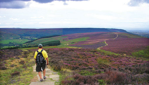
Described by many as one of the top ten hikes in the world, this classic walk is 190 miles of sheer hiking pleasure, taking in three national parks: the Lake District, where England’s highest mountains are found; the long green valleys of the Yorkshire Dales (of James Herriot fame); and the pink and purple heather of the North Yorkshire Moors. On our trip you’ll hike the entire 190 miles, not just sections as most other companies offer.
TRIP HIGHLIGHTS
- One of the ten best long-distance hikes in the world! (It should be on your life’s “to-do” list.)
- A full 190-mile hike from the Irish Sea to the North Sea across the historical and literary landscape of England (we offer the entire West to East route, not just sections)
- Storybook villages, rushing streams, verdant meadows, and the lovely mountains of the Lake District
- Explore the heart of three of England’s renowned national parks!
Loading map, please wait...
Locations visited/nearby
Walking England Coast-to-Coast , England, Europe
Special information
- May accommodate certain types of disabilities. Contact the operator for more information.
Itinerary
Day 1 : Penrith – St. Bees
Meet in Penrith, England, and transfer to St. Bees, a historic town dating from A.D. 650.
Day 2 : St. Bees to Ennerdale Bridge
Begin the hike, heading inland along the lakes and fells of the Lake District. Pass through Grasmere, Patterdale Valley, Lake Ullswater, and Kidsty Pike, at 2,558 feet the highest point of the walk.
Day 3 : Ennerdale Bridge to Rosthwaite
A day of lakeshore, forest, and mountainside, beginning with a splendid ramble along the southern shore of Ennerdale Water, Lakeland’s most easterly lake. Following are enticing place names like Black Sail Hut and Moses Trod, as we ascend into the Lake District proper. The day ends after descending from Honister Pass (1,163') to Borrowdale, considered by many to be one of the most beautiful valleys in the Lake District. (14½ miles; 1,800 feet of ascent.)
Day 4 : Rosthwaite to Grasmere
The day begins with a gentle walk along Stonethwaite Beck, a mountain stream running along the dominating profile of Eagle Crag, before pulling up to the 2,000-foot pass of Greenup Edge. From here, the view is filled by the immense switchback of the Helvellyn range, Lakeland’s second highest range of mountains. A short descent is followed by an ascent to Helm Crag (1,328'), then another descent to the Vale of Grasmere. (9 miles; 2,200 feet of ascent.)
Days 5 - 6 : Grasmere to Patterdale / Patterdale to Shap
Another relatively short day gives us time to enjoy the beauty of the surrounding lakes and fells of the Lake District. We’ll climb up from Grasmere over Grisdale Hause (1,936'), offering splendid views over Grisdale Tarn toward the foreboding ridge walk of Striding Ridge leading to the Hellvelyn summit. We descend to the picturesque Patterdale Valley, dominated by the enchanting reflections of Lake Ullswater, Lakeland’s second largest lake. (8½ miles; 1,800 feet of ascent.)
Day 7 : Shap to Ravenstonedale
Cross a limestone plateau interspersed with ancient stone circles, burial mounds, and prehistoric settlements. Continue through the Pennine Chain and the scenic Yorkshire Dales National Park, where little stone built villages nestle by streams on the valley floors.
Day 8 : Ravenstonedale to Keld
Passing by the intriguing Giants Graves and the Eden Valley, we now head for the Pennine Chain, a ridge of mountains and hills that form a backbone down the length of England. The town of Kirkby Stephen, sitting along our route, has a market charter dating back to 1351! Now it’s on to Nine Standards Rigg, at 2,171 feet our highest point of crossing the Pennines, before descending into the scenic Yorkshire Dales National Park. This national park is characterized by its sheep-populated, rolling green hills, with little stone built villages nestling by streams on the valley floors. Its limestone features and dry stone walls give it a picture book appeal.
Our destination is Keld, in Swaledale, in the heart of the national park, and there are lovely waterfalls (known as “force”) to be seen along the river Swale as we approach the village. Note—For those wishing to walk only the 6 miles to Kirkby Stephen, a taxi or minibus will be available to transfer you to Keld (cost not included). Our accommodation is at the highest inn in England! (18 miles; 2,300 feet of ascent.)
Day 9 : Keld to Reeth
On our journey across the Dales we first follow the river Swale through flowery meadows and enchanting stone villages as it descends into Swaledale proper. After lunch, we ascend to the old lead mining areas overlooking this beautiful valley, among them the intriguingly named “Surrender bridge.” Our destination is Reeth, the proud capital of Swaledale. Its inns and shops are a popular haunt for locals and tourists alike, and it even boasts a little folk museum. Many consider this the most picturesque day of the hike. (11 miles; 1,800 feet of ascent.)
# Ecc06
Day 10 : Reeth to Richmond
Today is easier as we continue through Swaledale to Richmond, passing an old priory, a couple of lovely villages, limestone geological features, and leafy streams. Richmond is a town steeped in history and dominated by the 11th-century Norman castle, with its imposing 12th-century keep. It’s an impressive sight towering over the town, which itself has 14th-century churches and a cobbled market place. The restored Georgian theater dating from 1788 may offer the chance to catch a play while we are here. (11 miles; 900 feet of ascent.)
Day 11 : Richmond to Danby Wiske
Only 200 feet of ascent today—a real contrast to the fells of the Lake District and the Pennines! Following the river Swale, we pass near the substantial ruins of Easby Abbey, which was founded in 1152 for a group of white canons of the Premonstratensions order, and was occupied until Henry VIII abolished the abbeys and monasteries in the 16th century.
Passing through the villages of Colburn and Catterick Bridge (once the home of a Roman garrison and now a modern garrison town, with a well known horse racecourse nearby), we reach the charming small village of Boltonon Swale. Here, in the village churchyard, is a memorial to Henry Jenkins, said to have been born in 1500, and died 169 years later! Perhaps a pint in the local pub will help to mull over this, before heading off to complete our day at Danby Wiske. (14 miles; 200 feet of ascent.)
Day 12 : Danby Wiske to Osmotherley
Traverse the North Yorkshire Moors National Park past the Cleveland Hills, the scarp cliffs of Hasty Bank, and on through Glaisdale High Moor to Glaisdale and the river Esk.
# Ecc02
Day 13 : Osmotherley to Blakey
We are in for a real roller coaster of a day along the Cleveland Hills, where ascent is followed by descent as we make our way through the sometimes bleak, often dramatic North Yorkshire Moors National Park for the last part of our journey. After an early start, we pass through Arncliffe wood and ascend to the escarpment for dramatic views over the flat Swaledale plain, before reaching Carlton Bank where a hidden café offers a mid morning warm snack (a distance of about 7 miles). We then pass through Cringle End and Cold Moor before reaching the crags and boulders of the Wainstones and the scarp cliffs of Hasty Bank. (19 miles; 2,900 feet of ascent.)
Day 14 : Blakey to Grosmont
A mostly downhill day as we descend to Great Fryup Head, where track ponies would earlier have carried coal from the pits scattered in the area, and on through the bracken of Glaisdale High Moor to the valley of Glaisdale and the river Esk. Glaisdale was a part of the iron ore boom of the 19th century, with three blast furnaces and a railroad nearby.
Nearby Beggars Bridge is a work of art. Its graceful arches above the river Esk date from the early 1600s, when it was used in the times of the packhorse. The path on goes through East Arncliffe Wood, and follows a centuries-old trade route through Eskdale and on to our day’s destination of Grosmont, in the Esk valley. (13¾ miles; 400 feet of ascent.)
Day 15 : Grosmont to Robin Hood’s Bay
End the hike at Robin Hood's Bay on the North Sea, with a welcome ritual bathing of the feet! Depart on Day 16.
Day 16 : Travel Home
Depart from York to London. Fly home.
More information from Mountain Travel Sobek:
- Email this trip page to a friend
-

Comments from Facebook