Mystery of the Rainbow, Navajo Indian Reservation, Arizona and Utah
- Navajo Mountain, UT, United States
- Active & Adventure

| from $995* per person | 7 Days | April |
| Comfort accommodations | Exertion level: 3 | |
| Operator: Sierra Club Outings | 12 people max | |
Early in the 20th century, the well known southwestern desert guide John Wetherill led various adventurers -- including author Zane Grey, clothing manufacturer Charles Bernheimer, and former president Teddy Roosevelt -- through Cobb's "disordered conglomeration" on the way to Rainbow Bridge. Zane Grey later described the route as having the most dangerous slopes he had ever seen. Roosevelt described tilted masses of sheet-rock ending in cliffs and difficult for both horses and men. Bernheimer, describing the route as "fiendish," wrote to his wife that there was nothing like it anywhere else.
We will hike to Rainbow Bridge and walk in the shadow of Navajo Mountain, but we won’t follow John Wetherill’s route. That route, known as the Rainbow Trail, is today traveled by possibly a hundred hikers every year. Our route is followed by no one. In comparison, it will make Wetherill's look as flat as Kansas.
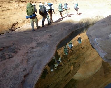
The trip will begin in Rainbow City on the east flank of Navajo Mountain. After starting on Wetherill's now well worn route, we will leave that route for the maze of cracks and slot canyons identified on early maps as Mystery Canyon. From this point on, our route is cross-country through a tortuous landscape that to this day has known very few non-native visitors.
Mystery Canyon is well protected from casual hikers. Its Colorado River terminus is a long blank wall. At its upper end, the canyon's three branches embrace a nearly 2,000-foot high sandstone battlement -- which history contains no record of having been climbed or crossed. All three branches are narrow, vertical slots with no easy, or easily found, routes in or out.
Our hike will take us into all three branches. All are relatively short and were it not for the pour-offs, plunge pools, ledges, cliffs and, in some places, nearly impenetrable vegetation, a motivated hiker could walk the length of each branch in a day. But the obstacles make this impossible without technical canyoneering skills and very nearly impossible even with them. We will backpack across the three branches of the canyon and day-hike in each of the branches where we can safely do so. We will see Anasazi ruins, moqui steps, pictographs, petroglyphs, a cave, a dinosaur, miles of slickrock and more vertical landscape per square yard than perhaps anywhere in the southwest.
Our last day begins with a short hike to Echo Camp -- now just a few rusting bed frames and disintegrating wood shacks, but graced with a lovely spring and a shallow pool surrounded by maidenhair fern. Soon thereafter, we reach Rainbow Bridge, the destination for John Wetherill’s trips and the highest and longest natural stone bridge on the planet. The trip ends with a leisurely boat ride across Lake Powell back to Page.
Loading map, please wait...
Locations visited/nearby
Arizona, Utah, United States
Itinerary
This eight-day hike will begin in Rainbow City on the shoulder of Navajo Mountain. Our Navajo friends will provide transport (not part of the Sierra Club trip) from Page, Arizona to our trailhead. The leader will provide detailed information regarding the meeting location, time, and the Navajo transport. The transport cost is approximately $60. Because the transport is not part of the Sierra Club trip, the cost is not included in the trip fee. ALL PARTICIPANTS NEED TO BRING CASH FOR TRANSPORTATION.Day 1: We will backpack about five miles, crossing Bald Rock and Cha Canyons, and camping in a large alcove with evidence of ancient habitation in Nasja Canyon.
Day 2: We descend a canyon named for the Paiute Indian (Nasja) who originally guided John Wetherill to Rainbow Bridge. After an optional day hike through a slot with deep water, we climb steeply out of the canyon, crossing to the upper end of Mystery Canyon where we will spend the night. Although our campsite is only about a half-mile from the previous night's campsite, we will need nearly the entire day to get there. We end the day by viewing our prior campsite from a 800-foot dome.
Days 3-4: We backpack to the other two branches of Mystery Canyon, camping and day hiking in the canyons.
Days 5-6: We backpack out of Mystery Canyon to Oak Canyon, and take a side-trip to an overlook. We will day hike on the sixth day to a high butte with 200-mile views if the weather is clear; we may also find dinosaur fossils and explore a cave with pictographs.
Day 7-8: We rejoin Wetherill's route, backpacking about half the seventh day to the upper end of Bridge Canyon. On the eighth day, we hike down Bridge Canyon to Echo camp and Rainbow Bridge, then return on the tourist boat to Page.
Except for the brief visit to Rainbow Bridge, this trip is entirely on land within the Navajo Nation. We will enjoy the area as guests of the local Navajo, and the Sierra Club will make a donation to the Navajo Mountain chapter house or school to express our appreciation.
The rugged nature of the landscape makes this trip more than an introduction to hiking the Colorado Plateau. Rather -- it is a mini-expedition through a rarely visited desert wilderness. Once we leave the Rainbow Trail, participants are committed to the entire trip. Other than by helicopter, leaving early is impossible (and even by helicopter it would be difficult). It is quite likely that we won't see anyone on this trip, except at the very end.
More information from Sierra Club Outings:
- Email this trip page to a friend
-


Comments from Facebook