10 Day Full Canyon (trip)

10 Day Full Canyon
- Bluff, UT, United States
- Boats, Barges & Small Ship Cruises
| from $2,318* per person | 10 Days | Year-round |
| Comfort accommodations | Exertion level: 3 | |
| Operator: Far Out Expeditions | 12 people max | |
Loading map, please wait...
Locations visited/nearby
Utah, United States
Special information
- This is a custom departure, meaning this trip is offered on dates that you arrange privately with the provider. Additionally, you need to form your own private group for this trip. The itinerary and price here is just a sample. Contact the provider for detailed pricing, minimum group size, and scheduling information. For most providers, the larger the group you are traveling with, the lower the per-person cost will be.
Itinerary
Evening Prior to Trip:At 7:00 pm the group meets for orientation at Wild Rivers Expeditions in Bluff. Here passengers meet guides who give an overview of the trip, daily schedules, safety procedures and provide answers to any last minute questions. Personal dry bags and boxes are passed out for the morning.
Day One:
At 8:30 we meet at Wild Rivers Expeditions in Bluff. We take vans to Sand Island to meet the boats and guides. We visit two archaeological sites, including spectacular rock art panels, prior to making camp near River House cliff dwelling. Interpretation focuses on providing an overview of the San Juan's rich prehistory and its various cultures (Archaic, Basketmaker and Ancestral Puebloan) evidenced in rock art, pot sherds and surface sites. Our evening discussion will focus on the riparian ecology of the river and how it has and hasn't changed since the construction of Navajo Dam and other upstream water diversions. We will also review the prehistory of the day and discuss the next day's itinerary.
Day Two:
After breakfast we hike to River House cliff dwelling, a Pueblo 2 dwelling a short walk from camp. We learn about Ancestral Puebloan lifeways and see firsthand the changes entailed by the shift from pre-agricultural agricultural cultures. We then hike downstream to a great kiva and several adjacent surface sites near comb ridge. Both sites, River House and the Great Kiva, evidence the height of the Ancestral Puebloan civilization. After lunch we'll hike up San Juan Hill, an historic road built by the Hole In the Rock Expedition in the late 1800s. Atop San Juan Hill, a short hike west finds us atop Comb Ridge. Commanding views in all directions afford an opportunity for wonderful photographs and an introduction to the region's geologic history. We return to camp for dinner in the late afternoon.
Day Three:
We break camp in the morning and make the quick float down to Chinle Wash. After unloading the boats and packing a hiking lunch, we make our way up into Chinle's canyon. Here we see rock art from Basketmaker and Ancestral Puebloan cultures, including Baseball Man, a protective shield symbol believed to have been superimposed by Ancestral Puebloan cultures atop a Basketmaker anthropomorph during raids just prior to abandonment (or migration). We'll also see protective dwellings built in alcoves amidst the cliffs high above the wash. Taken together, the rock art and dwellings in Chinle Wash tell the story of abandonment, or migration, and thus provide a fascinating and sobering conclusion to our learning about San Juan prehistory. In the late afternoon we return to camp for dinner. In the evening we have an introductory discussion on the region's geology, which is to be a focus of much of the rest of the trip.
Day Four:
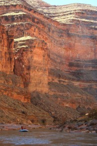
After breakfast we load the boats and make our way a few miles downstream. A day hike to the top of the diatreme affords spectacular views and fodder for a geology lesson. Looking north we clearly see the beginnings of the Monument Upwarp, a massive upward flexure in the Earth's crust. From east to west, over a hundred million years of geologic history is exposed in rock layers thrust skyward. The diatreme itself, a 30 million year old igneous intrusion, contains unique igneous rocks found nowhere else on the river. In the afternoon we'll make our way downstream seven miles to camp. Here the river incises into the Lime Ridge anticline, the easternmost expression of the Monument Upwarp, exposing limestones and shales 300 million years old. As the river cuts into the anticline it forms a spectacular gorge where native desert bighorn sheep are often seen. Our evening discussion will tell the story of this herd's miraculous recovery at the hand of conservation efforts by the Navajo Nation.
Day Five:
On day five we pass through the Lime Ridge and Raplee anticlines into the Mexican Hat syncline, where the river canyon again opens. In Mexican Hat we resupply our
coolers and make our way into the San Juan's lower canyon. Soon after Mexican Hat the river begins incising into Monument Upwarp, forming another beautiful gorge. We spend a considerable amount of time on the water on day five, resting our hiking legs and making our way well into the lower canyon. Our float takes into the heart of the Goosenecks State Park, where the river's meanders make for a circuitous route and one linear mile entails seven river miles. We make a fossil stop in the afternoon to look at giant chrinoid stems and other fossilized organisms. Our evening discussion will discuss how each layers exposed in the canyon evidence a unique depositional environment; and thus a unique environmental period in the evolution of what would become the Colorado Plateau.
Day Six:
Mid-morning we arrive at Honaker Trail, where we'll make camp. An historical miners' route, our hike up the Honaker trail affords spectacular views of the river gorge in addition to an up-close look at the alternating limtestones and shales in the canyon wall's stratigraphy. Building upon the previous evenings discussion, we can examine the differences in those rock layers and link them to different environmental conditions that occurred during the Pennsylvanian some 300 million years ago. For those willing to hike to the top of the trail, the view atop the rim affords a textbook view of some of the Colorado Plateau's most notable landforms; Cedar Mesa, the Chuska and
Charrizo Mountains, Alhambra Rock, Navajo Mountain and the Henry Mountains. For those interested in hiking a shorter distance, the "horn" makes for a spectacular stopping point with breathtaking relief and views of the river. In the evening we'll read Wallace Stegner's retelling of his Honaker Trail hike and San Juan River expedition in the late 1940s.
Day Seven:
On day seven we make our way to John's Canyon, passing through Ross rapid and "the 50s,"one of the lower canyon's deepest and most scenic sections. As our Honaker camp marks the apex of the Monument Upwarp, our day seven float will see rock layers slowly arcing downward back into the river. After lunch at Ross Rapid, we'll take a quick walk downstream to see a plaque honoring the late Kenny Ross, one of river runnings forefathers who was an astute archaeologist, geologist and founder of Wild Rivers Expeditions in Bluff. In the afternoon the river reaches it's highest gradient and there are frequent small rapids and ripples. If time affords, we may stop to hike up one
of the many spectacular side canyons entering from the north. And if luck affords, we may see members of a second population of desert bighorn sheep that frequent the river's southern bank. Our camp at John's canyon is beautiful, set in a particularly scenic stretch of the river. Just downstream a massive pour-off marks the mouth of John's canyon into the San Juan. Below it, where flood waters enter the river, exposed bedrock reveal a diverse array of fossils. Our evening discussion will probe more deeply into the processes and mechanisms that created the Monument Upwarp.
Day Eight:
By early afternoon on day eight we find ourselves at our camp at the mouth of Slickhorn Gulch. We'll unload boats and gather our day hiking gear for a walk up into Slickhorn. The canyon consists of a series of pools, waterfalls and hanging gardens. The water-sculpted limestone forms beautiful grottos and rivulets as we hike upstream. We will have time to read, photograph, draw, sit and visit with friends and perhaps also swim, water and weather willing. Slickhorn is a wonderful place to simply relax and take time to enjoy the canyon country aesthetic. Our evening will involve another delicious dinner and a discussion of the big geologic question of the trip: How exactly did the river get here?
Day Nine:
Slickhorn Gulch marks the end of the Pennsylvanian rocks and the beginning of the Cedar Mesa sandstone. The chunky mudstones and limestones of the previous sixty river miles are replaced by the harder, yellow sandstone and the canyon changes character yet again. Slickhorn Gulch also marks the historical upstream limit of Lake Powell, where it had backed up to during the high water year of 1983. Resulting sedimentation (caused by fast, sediment-laden water slowing and dropping sediment upon meeting the lake) has formed a large sediment delta that extends from Slickhorn to many tens of river miles downstream. As a result, the river's previous eight foot per mile gradient is replaced by a six inch per mile gradient: The river slows and meanders between the Cedar Mesa sandstone walls as we make our way downstream of Slickhorn. Day nine mimicks day eight; we do our floating in the morning with time in the afternoon for hiking either Grand Gulch or Oljato Wash, depending upon which camp we're assigned by BLM. Like Slickhorn, both make for beautiful hikes, photography, or just some relaxing personal time. Our evening discussion stands atop the shoulders of the sediment delta; we'll learn about the Colorado River Water Compact, Glen Canyon Dam and Lake Powell;a formative story whose long reaching effects on Colorado Plateau landscape and people are still very much in play. We'll also afford time for a selected reading, perhaps Ann Zwinger, and to reflect on the trip; our favorite places, most moving experiences, and funniest stories.
Day Ten:
Our last day on the river. Our bid farewell begins with an hour-long silent float amidst the soft morning light and narrowing walls of the Cedar Mesa sandstone. After ten days together the group is like a family or team; having spent more than a week together learning, hiking, floating, helping one another and sharing in humor and challenges
alike. Similarly, our senses are tuned into the canyon environment; from birdsong to the lapping water against walls and oars to the subtle textures of water-sculpted sandstone. The silent float affords all of this a dignified closure and one last spell of floating through canyon country. We meet our vans in the early afternoon. This provides enough time to return to Bluff to either get on the road or, as is often customary with a river trip, to clean up and meet for a group dinner prior to going our separate ways the next day.
More information from Far Out Expeditions:
- Email this trip page to a friend
-

Comments from Facebook