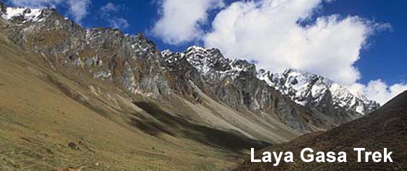
Laya / Gasa Trek (trip)

Laya / Gasa Trek
- Paro Airport, Paro, Bhutan
- Active & Adventure
| from $4,500* per person | 18 Days | February-June, September-November |
| Comfort accommodations | Exertion level: 3 | |
| Operator: Ace The Himalaya | 15 people max | |
Loading map, please wait...
Locations visited/nearby
Bhutan, Asia
0 testimonials about this trip.
3 testimonials about the provider, Ace The Himalaya:
-
Reviewer: Claire Love
located in
Dubai
We were a group of 4 girls wanting a challenge and that's exactly what we got...one that was tailored to our needs! Our Ace team led by Aakash KC did a sterling job getting us all the way to Everest base camp - having filled us with numerous mo-mos! The team were amazing managing to put up with our varied moods, humour and joining in the brithday celebrations! We were privaleged to have two guides with Dhruber always running ahead to secure our night's accomodation. An amazing trip, that made treking to EBC and Kalapattar a huge accomplishment! Thank you for making our experience an awesome one!
-
Reviewer: Colleen Shanahan and Michael Fischer
located in
Philadelphia
USA
We spent two and a half weeks hiking from Jiri to Everest Base Camp with guide Gyanu and porter Manoj and had a terrific experience. Gyanu was professional, experienced, and good company on the trail. He did a great job of being flexible (we changed our itinerary several times and he was very accommodating) and of making sure we were having the experience we wanted (from picking good lodges en route to scouting out fresh chicken when we were growing weary of dal bhaat to using his previous experience as a cook to make some terrific momos). His years of experience also meant he could answer any question - from Nepali politics to mountain naming to the local liquor to which lodge has good pizza. Manoj was equally good company, with a humorous charm and was eager to practice his developing English and guiding skills - we have no doubt he is on his way to becoming a great young guide. When we head to the Himalayas again, we would happy to go with Gyanu and Manoj.
As to the Jiri to Everest itinerary, we enjoyed having the experience of the week from Jiri to Lukla to get our trail legs and see some much quieter, less trekker-focused villages. We particularly liked Junbesi and Khari Khola. We might make one change: taking two days instead of one to walk from Jiri to Bhandar. We also enjoyed the Lukla to Everest base camp portion with it's spectacular views. Unfortunately, due to weather we did not go through Cho La pass to Gokyo so we will have to return to visit that area.
All in all, a great experience. -
Reviewer: Darlene Frazee
located in
1604 Honey Court,
USA
Just wanted to let you know what a wonderful time I had on the Everest Base Camp Trek. Not only was it an amazing hike through a beautiful country with wonderful people with which we could have never made it without our guides and porters. Bharat was our lead guide and I have to say the best guide I have ever had. He not only took care of us he made sure the porters were taken care of and he knew the people and cared for the environment. Dhurba was the other guide, he would go ahead of us to make sure we got a good place for the night and come back to walk with us, he was like Superman! Ace the Himalayas is a first class trekking company that cares about their clients, environment and the people of the region. I highly recommend them and will always use them when I visit here.
Itinerary
Day 01 - Arrival at Paro Airport.You will be met on arrival and transferred to your hotel to settle in. After lunch visit the Paro Dzong and the National Museum. The evening ends with a walk through Paro’s main shopping district. Overnight at the hotel.
Day 02 - Sightseeing around Paro
Day excursion of sightseeing to Taktsang Monastery / Tiger’s Nest, the most spectacular monastery and probably the most photographed one in Bhutan. It is said that Guru Rinpoche arrived here on the back of a tigress and meditated at this monastery hence it is called “Tiger’s Nest”. Lunch will be served at the cafeteria, followed by a short walk back. Evening at leisure. Overnight at the hotel.
Day 03 - Drive from Paro to Shana (start trek) Distance 15 km approx 5 hours
Drive up to Drukyel Dzong (north of Paro) where the motor-able road ends. The ruins of Drukgyel Dzong with Mount Chomolhari behind – a wonderful vista for the start of our trek. The trek to Shana starts along a dirt road for 1 hour through a wide, rich, cultivated valley, beneath forest-covered mountains, following the Paro Chu (river). The first small settlement encountered is Tsento Zampa, where the traditional Bhutanese farmhouses are bright red chillies drying on their roofs in season. Continuing on the east side of the river, gently through the forests alive with numerous birds and brightly colored butterflies. We reach the big military camp at Gunitsawa which has a school and some shops. Your trekking permit will be checked at the camp entrance. After 20 minutes you will see a big open field at Shana, near the river. Looking back from camp you can see a big snowy peak of Jo Drakey. Altitude of Shana 2890 Meters. Overnight at tented camp.
Day 04 - Trek to Thangthangka Distance 22 km Approx 7-8 hour
Today is a hard day, with a lot of distance to cover. The trail after lunch is rough and stony with many rises and drops. Following the river upstream we pass old ruins of Shana Bridge, destroyed by a major flood caused by glacial lake outbursts in 1950’s. The trail climbs steadily through a heavily forested area of oak, rhododendron, bamboo and ferns. After crossing a small house, Shing Karap is reached. Not far after Shing Karap, we pass a junction en-route, where another path leads up the easy, forbidden pass of Tremo La and onwards to the city of Phari in Tibet.
The trail makes a short steep climb and descent followed by a big bridge at 3250 m, crossing to the east side of the river is Thongo Zam, a possible lunch spot. The trek to Thangthangka continues through the forest consisting of birch, fir, larch, maple and blue pine. After a short climb we reach Seyende Zam where there is a big chorten (stupa). On clear weather we can see Mt. Chomolhari to the North. Further up about 20-30 minutes until we reach our camp in a meadow. Altitude of Thangthangka: 3575m. Overnight at tented camp.
Day 05 - Trek to Jangothang Distance 17 km Approx 4-5 hour
After enjoying the view to Chomolhari, the trail slowly leaves the forest line and gradually climbs into a beautiful valley, passing Tegethang, a winter home of yak herdsmen. Continuing until we arrive at Jangothang, Chomolhari base camp. This valley is wide and high with mountain views. Jichu Drake overlooks the camp which is nearby the ruins of an old fortress. Altitude of Jangothang: 4044m. Overnight at tented camp.
Day 06 - Rest Day in Jangothang
A rest day at Chomolhari camp to acclimatize. There are some good hikes from Chomolhari camp, and is important to take one hike today. The best walk is towards the east up to the twin lakes of Tsho Phu. From the lakes there is a spectacular view back to Chomolhari and Jichu Drake mountains. Watch out for a herd of Himalayan Blue Sheep in this valley. Overnight at tented camp.
Day 07 - Trek to Lingshid Distance 21 km Approx 6-7 hour
After breakfast a steep switchback trail starts climbing out of the valley into another that leads to the final climb and pass. It is a long climb about 3-4 hours to reach the high and very windy Nyelela Pass “sleepy pass” (4890m). From Nyelela Pass you can see far towards the east-northeast into the trekking area that we will be covering over the next couple of days. Mt. Takaphu dominates the view towards the north. Gangchen Ta “Tiger Mountain” is the main mountain to be seen looking east.
Less than 30 minutes down is a flat, more sheltered area – a good lunch spot. We continue to descend passing a narrow gorge with a small river crossing. The trail leads to a viewing point from which Lingshi Dzong can be seen. Our campsite is located next to a river. Altitude of Lingshi: 4010m Overnight at tented camp.
Day 08 - Trek to Chebisa Distance 16 km Approx 3-4 hours
This is the most pleasant walk of the whole trek. Leaving Lingshi we gently climb to another village, Gom Yu, set right below a 300m cliff. Another hour walk brings us to a little valley with a huge waterfall at one end of the Shangri La village of Chebisa, where we camp by the side of the river. Altitude of Chebisa: 3990mt. Overnight at tented camp.
Day 09 - Trek to Shakya Pasang Distance 14 km Approx 5 hours
The day begins with stiff climb to Gogu La (4,440m) then a long descent to a stream at 4,170m. It is a long climb over the ridge, the trail descends on a muddy path into Jholethang valley deep in the forest of fir and birch.The trail traverses high above the valley floor on stream to Chachim, a yak pasture at 4,260m. The camp is beside a stream at the bottom of the valley. Altitude of Shakya Pasang: 4000m. Overnight at tented camp.
Day 10 - Trek to Robkuthangd Distance 16 km Approx 7-8 hours
A long haul over the Jarela pass at 4785 m where we get stunning views of the Himalayan mountains. We drop steeply down a forest trail to the Tsarigathang valley, the summer residence of rare Himalayan Takin (Bhutan’s National animal). After crossing the stream, the trail ascends till you reach Robluthang camp at altitude of 4,160m. Overnight at tented camp.
Day 11 - Trek to Limithang Distance 14 km Approx 6-7 hours
This day is long as well as tough crossing Shinchela pass(5,000m/16,400 ft), the last and highest pass en route. You may be able to spot Blue Sheep high on the slopes, eagles, griffin vultures and yaks. The descent is a rough and rocky trail that follows moraine into another glacial valley. The last part of the trek is very interesting with fascinating views of Mt. Gangchey Ta. Our campsite is in a meadow by the riverbank. Altitude of Limithang 4,160m. Overnight at tented camp.
Day 12 - Trek to Laya Distance 9 km Approx 4 hours
A very pleasant walk to Laya with wonderful views along of the river, one of the tributaries of the Mochu. You will pass through a damp forest, filled with moss and singing birds. Arrive at Laya village, the second highest settlement in the country at altitude of 3,800m. Overnight at tented camp.
Day 13 - Rest day in Laya
The rest day is spent at your leisure or you can visit village houses and mixing with the Layaps. People in Laya are semi-nomadic yak-herders. In contrast to women in the rest of the country, Laya women wear their hair long and wear a distinctive dress made of yak hair and sheep's wool - a black skirt with brown vertical stripes, a black jacket a special conical bamboo hat. Overnight at tented camp.
Day 14 - Trek to Koina Distance 16 km Approx 6 hours
Descend to army camp and follow the Mo Chhu River till you cross the bridge after which it is up and down several times through juniper and fir forest until you reach the camp at Koina at an altitude of 3,240 m. Overnight at tented camp.
Day 15 - Trek to Gasa Hot Springs Distance 12 km Approx 6 hours
Beginning with a long climb to Balela pass (3900m). There is a small rock cairn and a few prayer flags at the pass. The route starts down again, through a bamboo forest to a stream. Later it is downhill all the way to Gasa Hot Springs. If time permits we will visit Gasa village and Dzong built in 17th century. Then descend to Gasa Hot Springs for camp at an altitude of 2,220m. Overnight at tented camp.
Day 16 - Trek to Punakha Distance 14 km Approx 4-5 hours
We climb away from Gasa Tsachu (hot spring) the trail winds through the hillsides with the vista of fields, villages and forests of oak and pine. Gasa Dzong will be visible behind you glued to the valley wall, seeming afloat in space. The trail descends from the high agricultural benches into a lush semi-tropical gorge above Damji village. Our transport meets us here, and we drive 3 hours to Punakha. Overnight at the hotel.
Day 17 - Drive from Punakha to Thimphu then onto Paro in the evening.
We visit the Punakha Dzong (the winter residence of Je Khenpo, the Chief Abbot and the central monastic body) then depart to Paro across Dochula pass. Lunch and sightseeing in Thimphu. Evening drive to Paro. Overnight at the hotel.
Day 18 - Transfer to international airport for your final departure.
After breakfast our Airport Representative will drop you to the Paro International Airport for your flight departure from Bhutan.
More information from Ace The Himalaya:
- Email this trip page to a friend
-

Comments from Facebook