Out of the Northwest Passage (trip)

Out of the Northwest Passage
- Kugluktuk Airport Kugluktuk, NU, Canada
- Active & Adventure
| from $7,195* per person | 17 Days | September |
| Comfort accommodations | Exertion level: 3 | |
| Operator: Adventure Canada | 12 people max | |
We will, ice conditions permitting, head through Prince of Wales Strait, making expeditionary stops on both Banks and Victoria Islands. Next we visit Winter Harbour and Nilson Griffiths Point on Melville Island and delve into the rich waters of Lancaster Sound, reputed for its abundance of beluga whales and other marine mammals. A stop at Beechey Island will bring us to the graves of the famed Franklin Expedition before heading into Smith Sound, where we will travel as far north as ice and time allows us before crossing into Greenland. Our voyage down the beautiful Greenlandic coast will include stops at Historic Melville Bay, the natural beauty of Kap York and the the quaint and isolated town of Ummannaq. Our final visit brings us to Ilulissat, the largest town in Disko Bay and a UNESCO World Heritage Site. We cruise among the massive icebergs, where North America's bergs calve from the massive Greenland icecap as it tumbles down to meet the sea.
Loading map, please wait...
Locations visited/nearby
Canada, North America
Itinerary
Day 1: Kugluktuk (Coppermine River)Situated on the famed Coppermine River, the hamlet of Kugluktuk is home to 1,200 residents. The proximity to the treeline make this area particularily rich in wildlife. Wolverines, moose, muskoxen, caribou, foxes, wolves and grizzly bears are all resident species. The people of Kugluktuk rely heavily on their traditional economy of hunting and fishing to feed and clothe their families for cultural and nutritional wellbeing. Originally named Coppermine, it was renamed Kugluktuk according to its Inuinnaqtun name meaning "place of moving waters", on January 1st, 1996. The Coppermine River itself is designated a Canadian Heritage River for the important role it played as an exploration and fur trade route. Copper deposits along the river attracted the first explorers to the area.
Day 2: Kangiryuar (Prince Albert Sound)
Found on the west side of Victoria Island, The Hudson's Bay Company post at Prince Albert Sound was opened in 1923, moved to Walker Bay in 1928 and finally to Ulukhaktok (Holman) in 1939. The large bluff that overlooks Ulukhaktok was the source that provided the slate and copper used to make ulus and give the community its name. Ulukhaktok is also the location of the most northern golf course in the Americas and hosts the "Billy Joss Open Celebrity Golf Tournament" every summer. Over the years they have managed to attract players from the Edmonton Oilers and the Edmonton Eskimos, as well as golfers from other countries.
Day 3: Banks Island
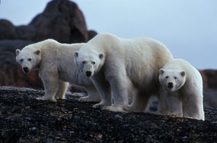
Home to two thirds of the world's population of Lesser Snow Geese, two federal Migratory Bird Sanctuaries were founded in 1961. The island is home to Barren-ground Caribou, polar bears, muskoxen, and birds such as robins and swallows. The first grizzly-polar bear hybrid found in the wild, was on Banks Island in April 2006 near Sachs Harbour. Muskoxen, with a population of about 40,000, are the most striking of the abundant wildlife on the island. It was named Banks Island in 1820 by Sir William Parry in honour of British naturalist and botanist Sir Joseph Banks.
Day 4: Prince of Wales Strait
Prince of Wales Strait is part of the Arctic Ocean, extending northeastward for 275 km from the Amundsen Gulf to Viscount Melville Sound and separating Banks and Victoria islands. It was discovered in 1850 by Robert McClure, the Irish explorer, who came within sight of the Viscount Melville Sound before heavy ice forced him to turn back. It was named after Albert Edward, then the Prince of Wales. It was not navigated until the RCMP patrol of Sgt Larsen in 1944. It has since become the preferred route of large vessels making the passage.
Day 5: Winter Harbour, Melville Island
Melville Island was first visited by British explorer Sir William Parry in 1819. Not only did he discover the island, ice forced him to spend the winter in 1820 at what is now called 'Winter Harbour'. The island is named for Robert Dundas, 2nd Viscount Melville, who was First Sea Lord at the time. Melville Island is one of two major breeding grounds for a small sea goose, the Western High Arctic Brant. DNA analysis and field observations suggest that these birds may be distinct from other brant stocks. Numbering only 4,000-8,000 birds, this is one of the rarest goose stocks in the world.
Day 6: Parry Channel
Parry Channel is a sea passage running east to west through the arctic islands. Named for explorer William Edward Parry, it begins at Lancaster Sound, passes through Barrow Strait, leads into Viscount Melville Sound, finally reaching the Beaufort Sea through M'Clure Strait. Here we will make an expedition stop at Nilson Griffiths Point.
Day 7: Bathurst Island
Good soil conditions and a rare wetland environment produce abundant vegetation here, making Bathurst a major calving area for the endangered Peary Caribou. Here we also find Polar Bear Pass National Wildlife Area, a migratory route for polar bears from March to November. The north half of the island is the proposed Tuktusiuqvialuk National Park. There is a long human history on the island, with evidence of Dorset and Thule habitation as early as 2,000 BC.
Day 8: Beechey Island and Radstock Bay
In 1845 Sir John Franklin took his expedition of 129 men in two ships into the Wellington Channel. Not a soul returned from the fateful expedition. It was two years before search parties were launched. Aside from the bodies of three souls buried here, only relics were found as clues to the disappearance. Until recently, the three graves had left no indication as to the fate of the rest of the British party. Such is the interest in this story, the Canadian government recently announced a new initiative to locate the missing Franklin vessels.
Day 9: Dundas Harbour and Croker Bay, Devon Island
The largest uninhabited island in the world supports significant concentrations of wildlife, including 26 species of seabirds and 11 species of marine mammals. At Dundas Harbour we find the lonely remains of an RCMP station dating from the 1920s. We have also spotted walrus, polar bear, muskox and caribou here. At nearby Croker Bay, we have a chance to Zodiac cruise though this scenic bay and marvel at icebergs, freshly calved from the glacier at the head of the bay.
Day 10: Aujuittuq (Grise Fiord)
Aujuittuq means 'place that never thaws,' and at 1,150km above the Arctic Circle, it is Canada?s northernmost civilian community. With a population of 165, we will be welcomed into this peaceful and warm hamlet. Our activities will center around the school where we will have a chance to meet members of the community and learn about their way of life.
Day 11: Smith Sound
We will spend a day exploring north into this fabled body of water that served as the main route for explorers and adventurers searching for the North Pole. Adolphus Greely, Sir George Nares and Elisha Kent Kane all travelled these waters with varying degrees of success. The Sound was named by William Baffin after Sir Thomas Smythe, promoter of voyages to find a Northwest Passage. Only 48-72km wide and 88km long, it is often packed with ice and provides favourable conditions for wildlife viewing.
Day 12: Cape Alexander
Arriving on the Greenland side of Smith Sound, we will have a chance to set foot on the westernmost tip of Greenland at Cape Alexander.
Day 13: Kap York
The rugged coastal environment at Kap York is rich in wildlife and is part of an extensive network of traditional hunting grounds. During the spring and summer months the skies and cliffs are dotted with millions of birds, primarily auks and murres. This district boasts the largest seabird population in northwest Greenland. Whalers and explorers often entered these waters and later Admiral Robert Peary's family raised a monument in honour of his achievements on the cape. Sailors' and ships' logs record multiple climbs of the cape in order to survey the ice conditions in Qimusseriarsuaq. We will hike the tundra landscape and enjoy our own magnificent vistas.
Day 14: Upernavik
Upernavik or "the spring place" is populated by 1,100 people most of whom make their living in the fishing industry this a few small fish processing plants line the harbor. Part of the population relies on polar bear hunting and sealing. Upernavik's location on the small island facing the open sea makes Upernavik unusual in comparison with other Greenlandic towns. Its location on the side of a hill provides a fantastic view of the Davis Strait. Of particular interest in the town is the cemetery. Here permanently frozen ground has forced the villagers to bury their dead in raised graves covered with rock and concrete. Just down the hill, near the Old Town Museum and church, you'll find the grave of Navarana Freuchen who died on the fifth Thule expedition with Knud Rasmussen.
Day 15: Itilleq
Living in a small town that relies primarily on fishing for its existence, Itilleq's residents are closely tied to the land and its resources. Beautifully coloured houses speckle the rocky landscape as the town's children play freely in rocky fields. We'll engage the local soccer team in a friendly match before parting ways.
Day 16: Ilulissat
250 km north of the Arctic Circle we find the stunning coastal community of Ilulissat. Ilulissat translates literally into "iceberg", and there couldn't be a more fitting name. Our visit will include time in the colourful town and a chance to hike out to an elevated viewpoint where we can observe the great fields of ice. We will also cruise in our fleet of Zodiacs in the UNESCO World Heritage Site of the Ilulissat Icefjord. The Icefjord is where we find the Sermeq Kujalleq Glacier, one of the most active and fastest moving in the world at 19m per day and calving more than 35 square kilometers of ice annually. The glacier has been the object of scientific attention for 250 years and, because of its relative ease of accessibility, has significantly added to the understanding of ice-cap glaciology, climate change and related geomorphic processes.
Day 17: Kangerlussuaq (Søndre Strømfjord), Greenland
We will make our journey down spectacular Sondre Stromfjord, and early risers will have a chance to experience the beauty of the fjord. Departing Kangerlussuaq, it is possible to see the largest ice cap in the world from your airplane window.
More information from Adventure Canada:
- Email this trip page to a friend
-

Comments from Facebook