
Denali
- Talkeetna, AK, United States
- Active & Adventure
| from $6,500* per person | 21 Days | May, June |
| Basic accommodations | Exertion level: 7 | |
| Operator: Adventure Consultants | 12 people max | |
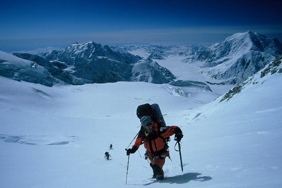
We offer guided expeditions ascending the West Buttress route of this spectacular mountain. Our North American based guides have extensive guiding experience on Denali and other high peaks around the world, making this an ideal expedition for those wishing to learn the essentials of high altitude mountaineering with the assurance of qualified leadership.
Our teams fly from Talkeetna to base camp on the southeast fork of the Kahiltna glacier at 7,000 ft / 2,134 m. From here we commence the climb of the West Buttress in traditional expedition style, establishing four or six camps on the mountain as part of our acclimatisation program prior to our summit bid.
An ascent of Denali is a challenging, yet incredibly rewarding experience.
North America's highest peak
Veteran Denali guides
Excellent high altitude training
Loading map, please wait...
Locations visited/nearby
Panhandle, Alaska, United States
0 testimonials about this trip.
3 testimonials about the provider, Adventure Consultants:
-
Reviewer: Stephen
located in
Canada
When I decided four years ago to complete the Seven Summits, I wanted to try a different guide company for all of my climbs until I found one that I was comfortable with, had the experience on all the summits and met all my expectations. After using three other companies, I am now in the process of planning my third climb with Adventure Consultants.
-
Reviewer: Dave
located in
USA
Good guides understand that part of the payoff is the opportunity to help create on of life's most powerful experiences for someone they've just met. I salute the guides of Adventure Consultants, who do just that every time they lead an expedition.
-
Reviewer: Dominic
located in
UK
May I take this opportunity to thank Adventure Consultants for putting me on top of the world on May 13, 2011, it was a lifelong ambition to climb Everest, and I only believe it starts to sink in 6 months later!
Itinerary
Weather and climbing conditions will dictate our progress during the climb. The itinerary is aguideline of our schedule.
Day 0 2pm gear check and orientation at the hotel in Anchorage. After the gear
check we will run any needed errands and guides will shop for fresh food items. There will
be an optional dinner at a local eatery in the evening.
Day 1 Depart for Talkeetna via a ground shuttle. The ride is about 2.5 hours with a
brief stop along the way. Once in Talkeetna (set altimeters for 358 feet) we will check in at
the ranger station and have an orientation and slide show from one of the Park Rangers.
After the orientation we will have lunch in town and pack for the glacier flight. We should be
able to fly onto the glacier and establish base camp in the afternoon. Once on the glacier we
will settle into Base Camp at 7200’/2194m on the Southeast Fork of the Kahiltna Glacier, and
discuss camp building, camp etiquette, cook tent procedures and the roles of each team
member on the expedition.
Day 2 After breakfast we will rig our sleds, dig our Base Camp cache, and head to
Camp 1 at 7800’/2378m below Ski Hill. Quick Stats: 5.5 miles, 1000’ of elevation gain (we
lose 400’ down Heart Break Hill below BC).
Day 3 Carry loads to cache at 10,000’/3048m feet near Kahiltna Pass below
Camp 2 (C2) and return to C1. Quick Stats: 7 miles round-trip, 2200’ of elevation gain and
loss.
Day 4 Move to C2 at 11,200’/3413m below Motorcycle Hill. Quick Stats: 4
miles, 3400’ of elevation gain.
Day 5 Retrieve our cache (back-carry) at 10,000’ and return to Camp 2. Quick Stats:
1 mile round-trip, 1200’ elevation loss and gain.
Day 6 Carry loads to cache around Windy Corner at 13,600’/4145m and return to
Camp 2. Quick Stats: 4.5 miles round-trip, 2400’ of elevation gain and loss.
Day 7 Move to Camp 3 (14 Camp) at 14,200’/4328m. The views of Mount Hunter,
Mount Foraker, and the sunset over the Alaska Range are incredible from this camp. Quick
Stats: 2.75 miles, 3000’ of elevation gain.
Day 8 Back carry the cache at 13,600’. Quick Stats: 1 mile round-trip and 600’ of
elevation loss and gain.
Day 9 Rest day. On this rest day at camp we practice using fixed lines and passing
running protection as a rope team in preparation for ascents of the fixed lines in the days to
come.
Day 10 Carry to 16,200’/4937m and cache above the top of the fixed lines. The fixed lines
protect about 800 vertical feet of 50 to 55 degree snow and ice on a feature call “The
Headwall.” Above the headwall we gain the crest of the West uttress that eventually leads to
High Camp at 17,200’/5242m. Quick Stats: 2.5 miles round trip, 2400’ of elevation gain and
loss.
Day 11 Optional rest day.
Day 12 Move to High Camp at 17,200ft/5242m. This is a long hard day. We will no
longer have the use of sleds and so all expedition gear must be carried in climber’s packs for
the ascent to High Camp. We will have the option of retrieving our cache on the way to
camp or returning to pick it up in the following days should the need arise. Quick Stats: 1.75
miles, 3000’ of elevation gain.
Day 13 Optional rest day. Most climbers need and want a rest day after the move to
High Camp.
Days 14-19 Summit days. The trip from 17,200’ to the summit (20,320’/6193m) will take
between 14 and 18 hours round-trip and is the hardest day of the expedition for most
climbers. It is not uncommon for teams to have to wait several days at High Camp for a
chance at the summit. Some teams never get a chance at the summit. High winds and very
cold temperatures are the norm and your time spent here will likely be miserable. Quick
Stats: 5 miles round-trip, 3120’ of elevation gain and loss.
Days 19-20 Descending days. It will take two full days to descend from High Camp back
to the landing strip. We need to be back at the landing strip by no later than 6am on the
morning of the 21st. day of the trip. Quick Stats: The descent from High Camp back to Base
Camp will cover 14 miles and 9800 feet of elevation loss. The last half-mile back to BC is
uphill (Heart Break Hill) and we will have to gain about 600’ before reaching BC.
Day 21 If the weather is good, we will fly off the glacier and sort gear in Talkeetna. It
is not entirely uncommon to be delayed for a day or more while waiting for the weather to
clear up enough for glacier planes to land. Upon return to town, most climbers opt to spend
the night in Talkeetna and enjoy one of the fine dining and drinking establishments with
fellow climbers in town. Lodging will be arranged when we get back to town and your guides
can help you make needed reservations for shuttle rides once we are settled in and
unpacked.
More information from Adventure Consultants:
- View trip on provider's website
www.adventureconsultants.com/adventure/Denali/… - Company profile, experience, and history
- View all of their trips
- Email this trip page to a friend
-

Comments from Facebook