Inca Trail trek to Machu… (trip)

Inca Trail trek to Machu Picchu
- Cusco Airport, Peru
- Active & Adventure
“Trip was amazing and went like clock work - thanks so much for all your help and advice. Will certainly… ”
| from $695* per person | 4 Days | March-January |
| Basic accommodations | Exertion level: 5 | |
| Operator: Andean Trails | 16 people max | |
The Vilcabamba range, approximately 85km long, is a really spectacular part of the Andes, located northwest of Cusco, between the Apurímac and Urubamba rivers. Several giant snow covered peaks rise out of the Vilcabamba massif, often clearly visible from the Lima to Cusco flight (sit on the left side of the plane) and also from the drive between Cusco and the start of the Inca Trail.
Salkantay (6,271m / 20,575ft) is the highest peak in the area, towering above all others. This mountain was highly revered by the Incas and is still very important to the people living in the Cusco area. Its name in Quechua means “wild mountain”. The other big snow covered mountain you see is Pumasillo (6075m), west of Machu Picchu and highest peak in the mini Sacsarayoc Range, seen from the second pass on the Inca Trail.
Inca history
Typical of the region is the verdant cloud forest of the rugged eastern side of the Vilcabamba mountains and the deep gorges of the Apurímac and Urubamba. They’ve been gouged out of granite by centuries of torrents of glacier melt water forcing their way north and eastwards on the way to the rainforest.
The area is rich in Inca history: for nearly 50 years this remote region served as a hideout for their resistance movement as it tried to regain control from the Spanish invaders in the 16th century. The Incas left behind many ceremonial platforms, gate houses (tambos) and a network of beautifully constructed pathways linking their strongholds, the well known Machu Picchu, and lesser known but equally important sites such as Choquequirau and Espiritu Pampa.
Loading map, please wait...
Locations visited/nearby
Peru
1 testimonial about this trip
-
Reviewer: Trish
located in
London,
England
Trip was amazing and went like clock work - thanks so much for all your help and advice. Will certainly recommend your company to others.
Best wishes
April 22, 2010
2 testimonials about the provider, Andean Trails :
-
Reviewer: Wendy Cheek
located in
USA
We had a WONDERFUL time – really incredible. All the folks we traveled/worked with were great. We really enjoyed Zacharias – he was very knowledgeable, and I really tested him on the plants! The only comment we would probably have was with the excursion to Taquile – I would have much rather spent more time on Amantani. It was really just a hike of the island and people watching…
I’m sure I’ll send back more comments as I get caught up back here! We really had a super time, and really look forward to another trip back to Peru. Let Tom know we’re thinking Galapagos for next April… J
Thanks!
-
Reviewer: Catherine McAvoy
located in
England
The Paine trek was fantastic. After hearing horror stories from other travellers about the gale-force winds & horizontal rain, I couldn't believe my luck when we had 4 days of blue sky and only a little bit of wind on the last day. Perfect.Our guide, Jay (Chaid is his real name I think, he's from turkey) was brilliant. He couldn't have done more for us, sorting out a few things in the hotel as well as making sure we didn't have to worry about anything other than putting one foot in front of the other. He also made the worlds best sandwiches! I said a big thank you but would be grateful if you could pass this on. So you couldn't have done a better job.Thanks again for your help with organising it all, I've got some great photos to make everyone jealous with (& just the one blister!)Catherine
Special information
- This is a custom departure, meaning this trip is offered on dates that you arrange privately with the provider. Additionally, you need to form your own private group for this trip. The itinerary and price here is just a sample. Contact the provider for detailed pricing, minimum group size, and scheduling information. For most providers, the larger the group you are traveling with, the lower the per-person cost will be.
Itinerary
Day 1: Transfer from Cusco, trek to Huayllabamba (12km trek)We pick you up early from your hotel in Cusco. After picking up all other trekkers you travel by bus, via the highland villages of Chinchero, Urubamba and Ollantaytambo, for the 3 hour journey to the start of the Inca Trail.
From the road there are great views of the Cordillera Urubamba mountain range and the snow capped peak of Veronica 5860m.
Most of our groups have up to 16 trekkers with one main English speaking guide and an assistant guide. Trekkers come from all over the world, and are of all ages.
At Chilca, where we start the trek, you walk down to the entrance, where your tickets are checked. Sign in, cross the bridge and make a left turn following the trail gently along the river bank until uphill we reach a eucalyptus grove and Llactapata - the first major ruins on the route. Vast retaining walls have converted the steeply sloping hillside into agricultural terraces: an amazing sight.
Just below Llactapata the Río Cusichaca, a tributary of the Urubamba, takes a spectacular plunge into the ground and runs through a subterranean channel for some way. The trail climbs steeply out of the ruins over a low pass, and the hike up the valley begins.
After about an hour you’ll reach a bridge, putting you on the other side of the valley, and will continue on to the village of Huayllabamba (3,000m). You will reach it in a further half hour. By this time it is likely to be very hot and you will welcome the cold drinks at the village which makes its living out of Inca Trail hikers. First night camp with basic facilities.
Day 2: Huayllabamba to Pacamayo (12km)
At Huayllabamba the trail turns right (northwest) up the Llullucha valley. After walking steeply upwards for about 11/2 hours you will drop down to a grassy clearing, popularly known as The Forks.
The path then enters woods – first scrub, then very beautiful cloudforest where the trees are hung with moss. These fairy-tale woods will help keep your mind off the fact that you are still going steeply uphill with no sign of respite. Eventually, however, the trees become more stunted and you emerge into a meadow, Llulluchapampa. From The Forks to the meadow is about 2 hours. This is the last campsite before the pass, aptly named (if you are a female hiker) Abra de Huarmihuañusqa, ‘Dead Woman’s Pass’ (4,198m), which you can see ahead of you.
It will take you about 11/2 hours to climb to the top of the pass. This is the highest point on the trail, so take heart – if you survive this, you’ll survive the other passes. Take time to look around you. You should be able to pick out the circular ruins of Runkuracay ahead, just below the next pass. The descent is steep but not difficult. Just follow the trail on the left side of the valley to the valley floor and the next designated campsite at Pacamayo (3,600m). Nearby are some huts with basic toilets and sinks built by the INC.
Day 3: Pacamayo to Wiñay Wayna (15km).
From the valley floor it will take you about an hour to reach the next set of Inca ruins. Runkuracay, a ruin not, perhaps, very impressive in itself, but occupying a commanding position overlooking the valley, and at the end of a series of rock-hewn steps that at last give you a feeling that you are on the trail of the Incas. From Runkuracay the path is clear over the second pass (Abra de Runkuracay, 4,000m) and, excitingly, much of the time you are on Inca steps. The descent down the steps is steep, so take care.
Just before the trail turns right, you’ll see the sign for Sayacmarca. These ruins lie about an hour from the top of the pass and the name, which means ‘the Inaccessible or Secret City’, is apt. You approach Sayacmarca up a superbly designed stone staircase. This is a diversion (the main trail continues its gradual descent to the right) but don’t let fatigue persuade you to miss it.
Like so many Inca ruins, no one really knows the purpose of Sayacmarca, but these are the visible facts: it was built on a precipice commanding a spacious view; there are no agricultural terraces so the complex could not have supported many inhabitants; ritual baths and an aqueduct run round the outside of the main wall; there are curious stone rings set in the wall by trapezoid openings. For us the mystery adds to the beauty, and it is beauty all the way from here – if you are fortunate with the weather.
The trail continues down to the valley floor. From here it becomes a glorious Inca Road, being on a raised causeway over marshy ground that then rises up through cloudforest. Stone paving on raised stone foundations, steps and a gentle gradient make for easy walking, and even if it is raining (and it often is) you will marvel at the Inca workmanship.
Before the climb to the third pass there is a campsite with basic toilets. During the ascent you climb through two Inca tunnels, and if it is a clear day you will have the added bonus of a view of Salkantay over to your left. The pass (3,700m) is used as a campsite, but it gets crowded and water is some way below. Just below the pass, about 2 hours from Sayacmarca, are the impressive ruins of Phuyupatamarca. Access is down a steep flight of stairs. Clear water runs through the channels cut into the rock that feed five baths, leading one from the other down the hill.
An Inca staircase leads from the west side of the ruins (the far end from the baths) and disappears into the jungle, leading you down a thousand steps. Literally. You’ll think that your knees will never feel the same again. The trek comes at the hostel nearby the ruins of Huiñay Huayna (Wiñay Wayna). This is the last camping spot before Machu Picchu and it is often very full. Basic camping facilities. There is a small restaurant. Beer! This is also the last place to fill up with water before Machu Picchu itself.
Huiñay Huayna lies just below the hostel round to the right as you are descending, and is the most extensive of the ruins so far. It has some beautiful stonework, a fantastic location, and an air of mystery often lacking in the crowded Machu Picchu ruins.
Day 4: Huiñay Huayna to Machu Picchu (5km), train to Cusco or hotel in Aguas Calientes
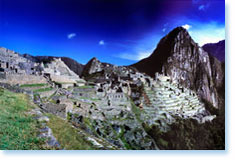
The trail from the hostel to Machu Picchu (11/2 hours away) is clearly marked. Most people have a very early start as they try to leave Wiñay Wayna by 5.30am so they can get to Machu Picchu before sunrise. The sky starts getting light by 6am and the first rays of the sun reach Machu Picchu around 7am. The trail contours a mountainside and disappears into cloudforest full of begonias, bromeliads and tree ferns, before coming to a steep flight of stairs leading up to the first Inca gate. The path continues to the main gate, Intipunku – ‘the Gateway of the Sun’ – and suddenly the whole of Machu Picchu is spread out before you. A magical moment.
When we arrive there is plenty of time to take photos of Machu Picchu. We walk down through the site to the main entrance where you can safely leave your backpacks. You can also use the toilet and have a drink in the restaurant just outside the entrance. We head back into the site for a complete tour of the major sectors of Machu Picchu. The tour takes about 2 hours so by about mid-morning you'll be free to continue to explore the ruins alone.
The train back to Cusco leaves from Aguas Calientes, the nearest village to the ruins of Machu Picchu, at approximately 16:30 and you get back into Cusco for about 21:00.
We suggest that after visiting Machu Picchu you take the bus down to Aguas Calientes at 15:30 at the latest (depending on your train departure time). Buses depart every 15 minutes. Check with the guide for actual times. This leaves you plenty of time at the site or to do one of the other walks nearby (see below for suggestions).
There are many restaurants in Aguas Calientes to satisfy all tastes and budgets. Of course you could also visit the hot springs that Agues Calientes is named for, which will help ease those aching muscles. Entrance to the springs costs US$2, and you should allow a couple of hours to fully enjoy them.
More information from Andean Trails :
- View trip on provider's website
www.andeantrails.co.uk/inca-trail-to-machu-picchu-peru-trek-r… - Company profile, experience, and history
- View all of their trips
- Email this trip page to a friend
-

Comments from Facebook