Aconcagua Normal Route (trip)

Aconcagua Normal Route
- Mendoza Airport, Mendoza, Argentina
- Active & Adventure
| from $4,350* per person | 20 Days | November, December |
| Comfort accommodations | Exertion level: 3 | |
| Operator: Mountain Madness | 12 people max | |
All of our equipment is carried to base camp by mules. We follow the philosophy of climb high and sleep low as we establish a series of higher camps while ascending Aconcagua. We have also built in numerous inclement weather days to the schedule to allow more time to attempt the summit climb. These factors enable proper acclimatization and greatly increase our chance for success.
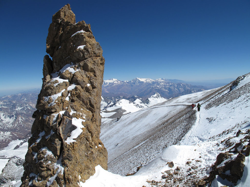
The Normal Route along the Northwest Ridge is a non-technical, yet physically demanding climb that incorporates all the logistics of climbing a big mountain. The ascent does require basic mountaineering skills. Expedition members should be versed in the use of ice axe and crampons and have strong backpacking skills. This is a challenging route for novice and experienced climbers alike and an ideal choice for those with some high altitude, general mountaineering experience such as Kilimanjaro, Mount Elbrus, and the Mexican or Ecuador Volcanoes.
Regardless of route choice, it is the high altitude and potentially extreme weather that challenge the climber ascending Aconcagua's slopes. The reward for your dedication and hard work is standing on the summit of the highest point in the Western Hemisphere.
The Normal Route is non-technical and follows the scenic Northwest Ridge of Aconcagua. The first recorded ascent of the route was in 1897, although there is some evidence that the ancient Incas climbed very high on the mountain and may have even reached the summit. This route begins at Plaza de Mulas, a vibrant base camp at the head of the Horcones Valley and utilizes three higher camps to gain the summit. We climb expedition style by acclimatizing while stocking camps before the final summit attempts.
Loading map, please wait...
Locations visited/nearby
Argentina, South America
0 testimonials about this trip.
3 testimonials about the provider, Mountain Madness:
-
Reviewer: Bill Alorets, Glacier Mountaineering Course
“Great trip! Lots of training and summit day was incredible. Lead and assistant guide was always available and incredible patient. I highly recommend Mountain Madness to anyone!”
-
Reviewer: Vince Colletti, Basic Rock Course
“I had one of the most amazing weekends of my life and our guide was responsible for that. I can’t say enough words of praise for him, or the staff of Mountain Madness. You definitely have a return customer!”
-
Reviewer: Angelina Trujillo, Mt. Baker Slow boat climb
“Thank you! This trip was very successful due to our guides and their support. My limited experience and older age was taken into account on how they managed our group which was the reason for all of our success!”
Itinerary
Day 1-2Overnight flight to Santiago, arriving in Mendoza in the morning or evening of Day 2.
Day 2
Elevation: 2,428 feet / 740 meters
Fly from Santiago to Mendoza. A Mountain Madness guide will meet you at the airport and escort you to the hotel in Mendoza. Exploring the charming city of Mendoza, in the heart of wine country, is always a highlight of this trip. This is a good day to wander about the town, enjoy the many parks, sidewalk cafes, delicious local cuisine, and take care of last minute details. Meet at the hotel in the evening for a group dinner and orientation.
Day 3
Elevation: 8,500 feet / 2590 meters
Leave Mendoza early and arrive at Puente del Inca mid afternoon - about four hours driving time. We will spend the night in dormitory style rooms near Puente del Inca. The name Puente del Inca comes from the impressive natural bridge which crosses the Rio de las Cuevas.
Day 4
Elevation: 11,200 feet / 3414 meters
We drive to the trailhead, just outside of town, and begin our approach to Aconcagua. All of our expedition food and equipment will be carried by mules, enabling us to enjoy this spectacular hike with a light daypack. The trail follows the Horcones River for 5 miles to the junction of the Lower and the Upper Horcones River. After crossing the Lower Horcones on a footbridge, we continue up the river valley towards Confluencia where we will set up our camp. We spend two nights at Confluencia in order to adequately acclimatize.
Day 5
Elevation: 13,200 feet / 4023 meters
After breakfast, we will day hike to Plaza Francia, which sits beneath the massive 10,000 foot South Face of Aconcagua, one of the world's most difficult alpine climbs. The path climbs gradually up this impressive valley on the lateral moraine of a beautiful glacial tongue flowing from the south face of Aconcagua. This is a great acclimatization hike and offers spectacular views of one of the largest rock and ice faces in the world! We then return to camp at Confluencia.
Day 6
Elevation: 14,300 feet / 4359 meters
We will complete the hike to our base camp, at Plaza de Mulas, by covering about 14 miles in 7 to 9 hours. Several stream crossings are met during the day and can be made easier if you have brought along a pair of sandals. This is a long and difficult day, but you will enjoy impressive views of Aconcagua, Cerro Cuerno, and the surrounding peaks. Mules carry the majority of the equipment and provisions to base camp.
Day 7
Today is scheduled for rest and acclimatization.
Day 8
Elevation: 16,200 feet / 4938 meters
Throughout our climb of Aconcagua we follow the philosophy of climb high-sleep low as we ascend the mountain. Today we carry gear up toward Camp Canada or Camp 1. From our base camp at Plaza de Mulas we follow the trail as it gradually switchbacks up steep scree slopes to the rock spires that mark Canada Camp. We cache food and gear here and then return to base camp. This usually takes 4 to 6 hours round trip.
Day 9
Elevation: 14,300 feet / 4359 meters
Today is dedicated toward rest, acclimatization and preparation for the summit push.
Day 10
Elevation: 16,200 feet / 4938 meters
We leave base camp and climb up the scree slopes once again to the pinnacles surrounding the flat promontory of Camp Canada. Next two nights at Camp Canada.
Day 11
Elevation: 18,400 feet / 5608 meters
Today we complete another carry of gear and food to Camp II or Nido de Condores. From Canada we make a long ascending traverse up toward an intermediate camp, Cambio de Penitentes. After a break we continue up toward the saddle between Aconcagua and Cerro Cuerno where Camp 2 is located. This is a large flat area with some large rocks that provide wind breaks. The view to the south, across a vast scree field called the Gran Acarreo, reveals the famous Canaleta couloir and the summit of Aconcagua. After making a cache, we descend to Canada for the evening.
Day 12
After breaking camp, we move our gear and ourselves to Nido de Condores.
Day 13
Elevation: 19,600 feet / 5974 meters
Our route from here ascends the subtle crest of the Northwest Ridge towards our Camp 3 (Berlin Camp). We will again follow the philosophy of carry high and sleep low and cache food and gear at Berlin Camp, then return to Nido de Condores.
Day 14
We move to Berlin Camp, our high camp on Aconcagua. The afternoon is dedicated to resting and getting ready for our summit attempt.
Days 15-16
Elevation: 22,841 feet / 6962 feet
Two summit days have been scheduled into the itinerary in case of bad weather at any part of the climb. In addition, day 18 can also be used as an alternate summit day if climbers return to base camp on that day.
Summit Day: From our high camp, the route continues along the Northwest ridge, passing the highest refuge in the world, Refugia Independencia, at 21,476 feet. From these ruins we continue climbing up and right, crossing the Cresta del Viento (Windy Crest). From here we traverse the upper part of the Gran Acarreo, which leads to the Canaleta; the most famous and challenging part of the Normal Route. The Canaleta is an approximately 30-degree scree gully that rises 1,300 feet and requires great patience and stamina. Above the Canaleta, you will find yourself on the Cresta del Guanaco, the ridge that joins the lower South Summit to the higher North Summit. We follow the ridge crest to the 22,841-foot true summit, where aluminum cross marks the highest point in the Western Hemisphere! The 360-degree view from the summit is awe-inspiring as you gaze out towards the numerous 20,000-foot peaks of the Andes. Summitting and returning back down to the Berlin Camp usually takes between 9-12 hours.
Day 17
Elevation: 14,300 feet / 4359 meters
We rapidly descend down the mountain, and marvel at how oxygen rich the air becomes with each 1,000 feet of elevation loss! Return to our base camp, Plaza de Mulas. 4-6 hours.
Day 18
Elevation 8,500 feet / 2590 meters
We get an early start and continue our descent as we hike out to Puenta del Inca, 10 to 12 hours. Overnight at the Hosteria.
Days 19
Elevation: 1,800 feet / 549 meters
Return to Mendoza for your flight home.
Day 20
Arrive home.
More information from Mountain Madness:
- Email this trip page to a friend
-

Comments from Facebook