Slackpacking Georgia (trip)

Slackpacking Georgia
- Airport near Atlanta, GA, United States
- Active & Adventure
| from $1,150* per person | 8 Days | October |
| Comfort accommodations | Exertion level: 3 | |
| Operator: Adventures in Good Company | 12 people max | |
returning to a comfortable bed and hot shower at the end of every day
enjoying sumptuous meals (that you don't have to cook!)
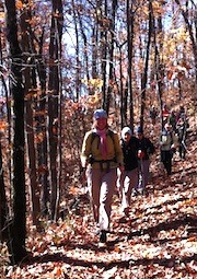
luxuriating in the fall foliage of northern Georgia
carrying only what you need for the day on your back
The Appalachian Trail truly has mythic status and for many of us, hiking it is a dream. But then we look at the reality of it and find the prospect of carrying a 40-50 pound pack on our back and sleeping on the ground rather daunting. Solution? Slackpacking! We cover the same distance as backpackers, but at the end of the day we return to a beautiful hostel with comfortable beds and hot showers as we traverse the Georgia section. We cover significant mileage on this trip so it still requires being in good shape.
Loading map, please wait...
Locations visited/nearby
Georgia, United States, North America
Special information
- Offers some women-only departures.
Itinerary
Sunday: We'll meet at the Atlanta airport at 1 pm. From there we'll take the metro to the spot where the shuttle picks us up and transports us to the Hiker Hostel, our home for the week. That evening we'll get to know each other and also review everything we need to know for our upcoming adventure to keep us safe and healthy.Monday: Springer Mountain to Hightower Gap
We start our hike at Springer Mountain (3,782 ft), the southern terminus of the Appalachian Trail. There are a couple of plaques at the top of the mountain and sweeping views of the Cohutta Mountains. And since it is the official start, its where we start. However, we cannot actually drive to Springer Mountain so we will need to first backtrack less than a mile from the first access point. Today's hike is mostly a long gradual descent followed by a not quite as long gradual ascent to the top of Hawk Mountain at 3,200 ft, before descending to Hightower Gap at 2850 ft. We'll see an AT shelter today as well as a beautiful waterfall. 9.30 miles. Elevation gain 1600 ft, loss 1310 ft
Tuesday: Hightower Gap to Woody Gap.
Our hike today is definitely more strenuous, with several steep ascents and descents as we climb up and over Sassafras Mt, Justus Mt, and Ramrock Mountain. Fortunately the toughest part is during the first half and after that it mellows out a bit. This part of the trail is the perfect introduction to the up and down nature of hiking in the northern Georgia mountains. 11.8 miles. Elevation gain 3400 ft, loss 1450 ft
Wednesday: Woody Gap to Neels Gap.
The high point of today's hike, both literally and metaphorically, is Blood Mt. At 4,461 ft it is the highest point of the Georgia section. There are a couple of warm ups first as we go up and over Gaddis Mt and Turkey Stamp Mt before the final 900 ft climb to the top. Blood Mt is full of history and we'll be glad to take a rest as we ponder the history that gave it its name. From there it's all downhill to Neels Gap and the great little outfitter store where we can buy maps, tshorts, or anything else you've decided you need. 10.7 miles. Elevation gain 2800 ft, loss 2480 ft
Thursday: Neels Gap to Hogpen Gap
After the last 3 days, we will be ready for this relatively short day! Known for open ridge tops with excellent views and fall wildflowers, the well-graded trail makes this a pleasant hike. However, its not flat. This section we will hike southbound. After about 1 mile of hiking, we'll have a challenging climb to Cowrock Mountain, where you'll be rewarded with magnificent views! There will be one more notable ascent to the top of Levelland Mountain before we finish the day with a downhill run into Neels Gap. We should be able to complete this part in a half day so today is the perfect time to visit the nearby charming town of Dahlonega. We'll drop you off and dinner is on your own tonight. 6.4 miles Elevation gain 1800 ft, loss 1400 ft
Friday: Unicoi Gap to Dicks Creek Gap
Are we really hiking 16 miles today? Maybe, maybe not. The first section is 4 miles and includes two climbs that are over 1,000 feet, with another optional 500 ft climb to the summit of Tray Mt. Luckily, there is road access at Tray Gap. Starting here will cut 4 miles and about 1500 feet of elevation gain off of today's hike, making it a 12 mile day instead. These 12 miles go through remote wilderness as it traverses from the second highest mountain on the section to the lowest gap on the trail. Today we come to understand the meaning of PUDs (pointless up and downs) as we go up and down and up and down and up and down etc for an elevation gain of 1900 feet. 16.1 miles. Elevation gain 5200 ft, loss 4000 ft
Saturday: Hogpen Gap to Unicoi Gap.
Today's hike starts and ends with traversing over humps; you definitely are going up and down but it is not nearly as steep as previous days, with the exception of a steep descent into Unicoi Gap. In between it is more undulating, with smaller ups and downs and one 4 or 5 mile stretch that follows an old road bed with a gentle gradient. It is a long day, though, and we'll be glad to see our shuttle waiting for us at the end. Tonight we'll go into town to celebrate our accomplishments (and our well-toned quads!) with a final farewell dinner. 13.6 miles. Elevation gain 2850 ft, loss 3175 ft
Sunday: You are free to leave anytime after breakfast. If you are flying out, we will have you back to the Atlanta airport by 11 am and you can plan a flight out after 12:30
More information from Adventures in Good Company :
- View trip on provider's website
www.adventuresingoodcompany.com/trip_display.php?id=221… - Company profile, experience, and history
- View all of their trips
- Email this trip page to a friend
-

Comments from Facebook