Into The Northwest Passage 2012 (trip)

Into The Northwest Passage 2012
- Kangerlussuaq Airport, Kangerlussuaq, Greenland
- Boats, Barges & Small Ship Cruises
| from $6,995* per person | 15 Days | August |
| Comfort accommodations | Exertion level: 3 | |
| Operator: Cruise North Expeditions | 12 people max | |
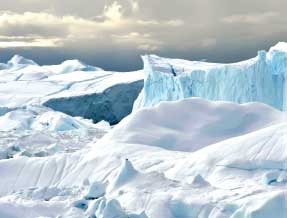
Our journey begins in Kangerlussuaq, Greenland, as we make our way through one of Greenland’s longest, and arguably most beautiful fjords, crossing the Arctic Circle in the process. As we make our way north along Greenland’s shore, we’ll have the opportunity to sail the coast, dotted with the colourful houses typical of Greenlandic communities. A highlight will be our visit to the UNESCO World Heritage Site of the Ilulissat Icefjord, where we will cruise amongst the icebergs, and marvel at the ice fields.
Our first stop in Nunavut is at the picturesque community of Mittimatalik (Pond Inlet). We’ll be treated to a cultural presentation here, including throat singing and traditional Inuit games, before exploring the town. From here we enter the mouth of the famed Northwest Passage! We’ll keep a keen eye out for narwhal and walrus before landing on Devon Island, where we’ll find spectacular Croker Bay and the Dundas Harbour RCMP historical site. Arriving at Beechey Island we visit the home of the graves from the lost Franklin Expedition, and a base for many rescue missions, passage seekers and modern explorers.
Sailing down the coast of Somerset Island, we’ll cruise through Bellot Strait seeking out whale and polar bear. Making landfall in Taloyoak, we continue to follow in the path of famed explorers. Formerly known as Spence Bay, the area has a long history of exploration, including the famed John Ross expeditions in the 1830s that resulted in the pinpointing of the Magnetic North Pole. The area later became central in the search for the legendary Franklin Expedition.
Join us in tracing the passage that conjures a history at once tragic and inspiring, a history encompassing hardship and death, but also courage, determination, and superhuman endurance.
Loading map, please wait...
Locations visited/nearby
Canada, Greenland
Itinerary
Day 1Kangerlussuaq (Sondre Stromfjord)
Lying at the head of the longest fjord in western Greenland, Kangerlussuaq has one of the most stable climates in the region though temperatures can range from -50C in the winter to as high as 28C in summer. Kangerlussuaq, which means 'The Big Fjord' in Greenlandic, is appropriately named, as it's 168km long and is the start of our voyage.
Day 2
Sisimuit Coast
The west Greenland coastline is a rich mixture of fishing communities, myriad islands and complex coastal waterways. We will be making an expedition stop here to explore the Greenlandic landscape
Day 3
Ilulissat
Venturing 250km north of the Arctic Circle we find the stunning coastal community of Ilulissat. Ilulissat translates literally into "iceberg", and there couldn't be a more fitting name. Our visit will include time in the colourful town and a chance to hike out to an elevated viewpoint where we can observe the great fields of ice. We will also cruise in our fleet of zodiacs in the UNESCO World Heritage Site of the Ilulissat Icefjord. The Icefjord is where we find the Sermeq Kujalleq Glacier, one of the most active and fastest moving in the world at 19m per day and calving more than 35 square kilometers of ice annually. The glacier has been the object of scientific attention for 250 years and, because of its relative ease of accessibility, has significantly added to the understanding of ice-cap glaciology, climate change and related geomorphic processes.
Day 4
Karrat Fjord
In Karrat Fjord we will cruise one of Greenland's most spectacular fjords. During ice breakup, narwhals and seals use the long leads created by high winds in this region to hunt the rich waters of the fjord. The cliffs within the fjord should give us good opportunities to see colonies of dovekies. Time spent on deck today should result in some good wildlife sightings, not to mention unbeatable photographic opportunities
Day 5
Upernavik
Upernavik means 'springtime place'. This was where people came in spring, when the ice broke up, to trade, fish and to drive the catch out to the open sea. Qaarsorsuaq Mountain, the town's landmark, can be seen up to 10km away.
Day 6
Mattimatalik (Pond Inlet)
We will sail through Milne Inlet, a narwhal breeding ground, enroute to Pond Inlet. This bustling Arctic community is surrounded by one of the most beautiful landscapes in the Eastern Arctic. We will have a chance to explore the town, as well as take in a cultural presentation at the Nattinnak Centre.
Day 7
Dundas Harbour
The largest uninhabited island in the world supports significant concentrations of wildlife, including 26 species of seabirds and 11 species of marine mammals. At Dundas Harbour we find the lonely remains of an RCMP station dating from the 1920s. We have also spotted walrus, polar bear, muskox and caribou here.
Day 8
Beechey and Prince Leopold Island
In 1845 Sir John Franklin took his expedition of 129 men in two ships into the Wellington Channel. Not a soul returned from the fateful expedition. It was two years before search parties were launched. Aside from the bodies of three souls buried here, only relics were found as clues to the disappearance. Until recently, the three graves had left no indication as to the fate of the rest of the British party. Such is the interest in this story, the Canadian government recently announced a new initiative to locate the missing Franklin vessels. Prince Leopold Island Prince Leopold is known as the 'Island of Freedom,' the vertical cliffs of Prince Leopold Island rise about 250m. The island was first sighted in 1819 by W.E. Parry, and named in honour of His Royal Highness Prince Leopold Saxe Coburg. The island is noted for its extraordinary bird cliffs that house Thick-billed Murres, Northern Fulmars, and Black-legged Kittiwakes, who care for their young chicks on nests glued to the rocks with guano. The colony is estimated at a quarter of a million birds. Other species known to breed on the island include Atlantic Brant, Common Raven, Common Eider, Parasitic Jaeger, Glaucous Gull, and Snow Bunting. The seabirds generally occupy the site from early May to the end of August. The entire island is included within the Prince Leopold Island Migratory Bird Sanctuary (Federal Crown Land). It encompasses 311 square kilometers, which includes a 5km marine buffer around the island
Day 9
Bellot Strait
Bellot Strait marks the first meeting of the Atlantic and Pacific tides north of Magellan Strait. Suprisingly, the strait was missed by John Ross and wasn't discovered until 1852 by William Kennedy, who named the strait after his second-in-command, Joseph-Rene Bellot.
Day 10
Taloyoak
The Inuit name Taloyoak describes an ancient stone blind that was used by hunters to herd caribou for the kill. Taloyoak, on the west coast of the Boothia Peninsula, is at the heart of the Northwest Passage. Formerly known as Spence Bay, the area has a long history of exploration, including the famed John Ross expeditions in the 1830s that resulted in the pinpointing of the Magnetic North Pole. The area later became central in the search for the legendary Franklin Expedition. Taloyoak’s present attractions are primarily its landscape, history, and fish and wildlife resources. The landscape is great for hiking. ATV and foot trails provide easy access to popular fishing and camping spots at nearby lakes. Artists, carvers and artisans are prolific in the area, and create mystical carvings in bone, ivory, and stone. Spence Bay ‘packing dolls’ – Arctic animals carrying their young in amautiit (hoods of traditional Inuit parkas) contribute to the local economy.
Day 11
Rae Strait
Rae Strait, named after Arctic explorer John Rae, is a small strait in the Kitikmeot Region of Nunavut, Canada. It is located between King William Island and the Boothia Peninsula on the mainland to the east.
Day 12
Queen Maud Gulf
The Queen Maud Gulf Migratory Bird Sanctuary contains the largest variety of geese of any nesting area in North America. The Sanctuary is one of the few nesting areas for both the Atlantic Brant (Brant bernicla hrota) and Pacific Brant (Branta bernicla nigricans). Almost the entire population of Ross' Goose (Chen rossii) nests here. It was named by Norwegian explorer Roald Amundsen in 1905 for Maud of Wales, the Queen of Norway. The Ahiak Caribou calve along the Queen Maud Gulf coast in Nunavut and spend the summers here. Here we may also find bald eagles, muskox and grizzly bears.
Day 13
Bathurst Inlet
Before there were any permanent buildings at Bathurst Inlet, the area was home to the Kingaunmiut, the "people of Nose Mountain". They constructed stone tent rings, meat caches, fox traps and drying racks, as well as hunting hides (taluit) and inuksuit (stone figures, "in the likeness of a man"). Few explorers reached this area - the first Franklin Expedition (1819-1821) came into Bathurst Inlet in the summer of 1821, travelling by large birchbark canoes, mapping the arctic coast and seeking the Northwest Passage. They were also seeking the local Inuit but found no one; everyone had gone inland for the summer. In 1936, the Hudson's Bay Company moved their trading post from the Western River area to Bathurst Inlet; the same year a Roman Catholic Church opened a mission. Both the trading post and mission operated until the mid 1960s.
Day 14
Coronation Gulf
Located between Victoria Island and the Arctic coast of mainland Canada, the Coronation Gulf is an extensive body of water that is linked to the Arctic Ocean via the Dolphin and Union Strait on the west and by the Dease Strait and Queen Maud Gulf on the east. Inside Coronation Gulf lies the Duke of York Archipelago. Rivers that flow into the gulf include the Rae, Richardson, Coppermine, and Tree. The mainland south of the gulf may have substantial diamond and uranium deposits. The small settlement of Kugluktuk lies at the mouth of the Coppermine River. The gulf was named in 1821 by John Franklin in honour of the coronation of King George IV. The environment and Native culture of the gulf was studied by Rudolph Anderson and Diamond Jenness in 1916 as part of the Canadian Arctic Expedition.
Day 15
Kugluktuk (Coppermine River)
Located at the mouth of the Coppermine river to southwest of Victoria Island on the Coronation Gulf, Kugluktuk is the western most community in Nunavut. Originally named Coppermine, it was renamed Kugluktuk according to its Inuinnaqtun name meaning "place of moving waters", on January 1st, 1996. The Coppermine River itself is designated a Canadian Heritage River for the important role it played as an exploration and fur trade route. Copper deposits along the river attracted the first explorers to the area. Because the tundra is close to the tree line, a variety of wildlife can be viewed in the area, including grizzly bears, wolverines and moose, as well as tundra wildlife, such as muskoxen, caribou, foxes and wolves.
More information from Cruise North Expeditions:
- Email this trip page to a friend
-

Comments from Facebook